| Stream Data: | Gage height, discharge |
| Water-Quality Data: | Water temperature, specific conductance, pH, dissolved oxygen, turbidity, nitrate plus nitrite, orthophosphate as phosphorus |
| Atmospheric Data: | Precipitation |
| Latitude: | 41°10'58" |
| Longitude: | 87°20'25" |
| Hydrologic Unit Code (HUC): | 07120001 |
| Datum: | 627.94 feet above NAVD88 |
| Drainage Area: | 1,779 square miles |
| County in which site is located: | Newton |
| Site managed by: | Indianapolis Office |
This station is operated and maintained in cooperation with the Indiana Department of Environmental Management and the U.S. Army Corps of Engineers - Chicago District.


In Indiana, the Kankakee River has a total drainage area of 1,920 square miles. From its source in northern Indiana, the Kankakee River flows westward through several Indiana counties and into Illinois. It is a tributary of the Illinois River and is within the Mississippi Watershed. Major tributaries to the Kankakee River in Indiana include the Yellow River.
The Kankakee River lies in the Northern Moraine and Lake physiographic region of Indiana where the surficial geology consists of stratified sand and gravel. Historically, much of the Kankakee River in Indiana and Illinois meandered through an area called the Grand Marsh. By the early 20th century the entire main stem of the river in Indiana was extensively channelized to lessen flooding and drain swampland areas for agriculture.
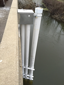
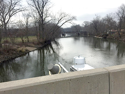
The super gage, Kankakee River at Shelby, deploys a multi-parameter sonde to collect continuous measurements of water temperature, specific conductance, pH, dissolved oxygen, and turbidity. Other monitors are deployed which continuously measure nitrate plus nitrite and orthophosphate. Measurements are collected every 15 minutes and update to the web hourly. Additionally, hydrologic technicians collect water-quality samples to represent a variety of hydrologic and seasonal conditions. Samples are analyzed for concentration of suspended sediment, nitrogen, and phosphorus.
Concentrations from laboratory analysis and corresponding values from in-stream instruments are mathematically combined to develop a statistical surrogate model. Then, this model is used to compute real-time concentrations based on continuous in-stream sensor readings of another, more easily measured value. For example, turbidity is a typical in-stream measurement used as a surrogate for suspended-sediment concentration. Daily, monthly, and annual loads can be computed and compared to understand seasonal and annual variability.
Over time, the quality of the Kankakee River and its tributaries (Yellow and Iroquois Rivers) has been altered by excess sedimentation from channelization and land use practices. A major concern to local residents and users of the Kankakee River is that sedimentation is limiting the recreational, ecological, and overall usefulness of the river. Nutrients and sediment are transported downstream, often crossing state and national borders.
The Indiana Department of Environmental Management (IDEM) seeks to implement federal and state regulations to protect human health and the environment while allowing the environmentally sound operations of industrial, agricultural, commercial and government activities vital to a prosperous economy. IDEM manages the states resources and is also concerned about interstate transport of nutrients and sediment. In 2015, IDEM asked the USGS to install, operate, and maintain a super gage on the Kankakee River at Shelby, IN. The gage will quantify concentrations and loads of sediment and nutrients being transported by the Kankakee River within Indiana and to the state border.
USGS Fact Sheet 2015-3041 provides more detailed information about super gages, how they operate, and the data they collect.
Indiana:
Tim Lathrop
(317) 600-2782
trlathro@usgs.gov
Kentucky:
Jeff Woods
(317) 600-2762
jwoods@usgs.gov