| Stream Data: | Gage height, discharge |
| Water-Quality Data: | Water temperature, specific conductance, pH, dissolved oxygen, turbidity, nitrate plus nitrite |
| Atmospheric Data: | Precipitation |
| Latitude: | 38°29'23" |
| Longitude: | 87°33'00" |
| Hydrologic Unit Code (HUC): | 05120202 |
| Datum: | 382.77 feet above NGVD29 |
| Drainage Area: | 11,305 square miles |
| County in which site is located: | Gibson |
| Site managed by: | Indianapolis Office |
This station is operated and maintained in cooperation with the USGS Groundwater and Streamflow Information Program and the USGS National Water-Quality Assessment Project.
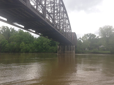
The White River at Hazleton, Indiana, is located on the Gibson County/Knox County line, in southern Indiana. The White River’s headwaters reside in the East Fork White River and West Fork White River Basins, which originate in east central Indiana. The forks merge at the county boundaries for Knox, Daviess, and Pike counties in southern Indiana and form the main stem of the White River.
The White River at Hazleton has the largest watershed of the super gages in Indiana, draining 11,305 square miles, including the city of Indianapolis. Despite draining a major metropolitan area, this watershed is comprised primarily of agricultural land. The placement of this site in southern Indiana allows for the water-quality characterization of a major river draining much of central Indiana. The streamflow gage and water-quality instrumentation located at this site near the state border help us understand the quality of water leaving the state and help quantify the transport of sediment, nutrients, and other contaminants across state boundaries.
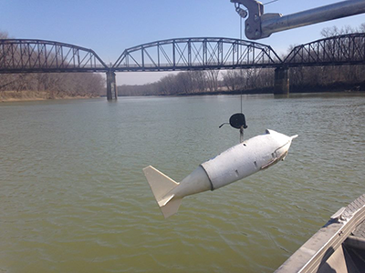
The super gage deploys a multi-parameter sonde to continuously collect water temperature, specific conductance, pH, dissolved oxygen, and turbidity. A nitrate monitor is also deployed that collects continuous nitrate plus nitrite data. Additionally, precipitation and gage height, a measurement of water elevation is used to compute streamflow, are collected.
Discrete water-quality samples of suspended sediment, nutrients, major ions and pesticides are collected at this site 18 times per year. Discrete samples are time-weighted such that samples are collected more frequently during the growing season.
Continuous water-quality measurements and discrete samples collected at this site are combined to create statistical surrogate models. Models are developed to relate in-stream instrument measurements to discrete constituent concentrations determined from laboratory analysis. After peer review and approval, a model can be used to continuously compute constituent concentrations based upon real-time continuous water-quality measurements.
In 2014, a model was developed and approved which statistically relates continuous real-time turbidity data and discrete samples of suspended sediment concentration. The model provides real-time estimates of suspended sediment concentration and loads. These data can be accessed in the links to real-time data on this page. More information about the super gages in Indiana and Kentucky and information about surrogate development can be found here.
The White River at Hazleton has been sampled regularly as part of the National Water-Quality Assessment (NAWQA) Program since 1991. The NAWQA program seeks to provide an understanding of water-quality conditions throughout the nation by collecting representative discrete water quality samples at sites located in the major river basins of the United States. This White River site is classified as a national “Status and Trends” site and is sampled in tandem with other sites across the Nation to determine if water-quality is changing over time and determine the effect of natural and human activities on stream conditions.
The Ohio Kentucky Indiana Water Science Center sought to take advantage of the high frequency sampling at this important site by adding continuous water quality monitoring instrumentation. The NAWQA and National Streamflow Information Programs support monitoring at this site, allowing the Water Science Center to supplement discrete samples with real-time information and provide further study of the quality of water leaving Indiana. Data collected at this site also promote understanding of how Indiana’s water quality contributes to the larger Mississippi River Basin watershed.
USGS Fact Sheet 2015-3041 provides more detailed information about super gages, how they operate, and the data they collect.
Indiana:
Tim Lathrop
(317) 600-2782
trlathro@usgs.gov
Kentucky:
Jeff Woods
(317) 600-2762
jwoods@usgs.gov